Pete's Walks - Hertfordshire Chain Walk
If you are considering walking this route yourself, please see my disclaimer. You may also like to see these notes about the maps and GPX files.
Walk 13 15/11/06 Sandon going south (5 miles each way, plus 5.5 one way)
Parked outside church in Sandon.
As I mentioned in the last journal entry, today I walked Walk 13 of the Hertfordshire Chain Walk both ways, and also walked Walk 12 in an anti-clockwise direction, making this a 15.5 mile walk. Over the course of this and the previous walk I have thus walked Walks 11, 12 and 13 in both directions.
I set off from home a few minutes later than usual this morning, and didn’t start walking until about 10.10am. As I was lacing up my boots, I realised I had a slight headache – this lasted most of the morning, despite taking a tablet for it about 11am. I think it was due to tiredness – I’d had a late night and then struggled to get to sleep as I’d been to a concert (the excellent Be Good Tanyas at The Stables in Wavendon, a small venue near Milton Keynes set up by the Jazz musicians Johnny Dankworth and Cleo Laine). It was grey and gloomy as I started walking, with lots of dark grey clouds, and remained like this for most of the day – about 11.30 the skies were almost clear and it was very sunny, but within half an hour it was almost overcast again.
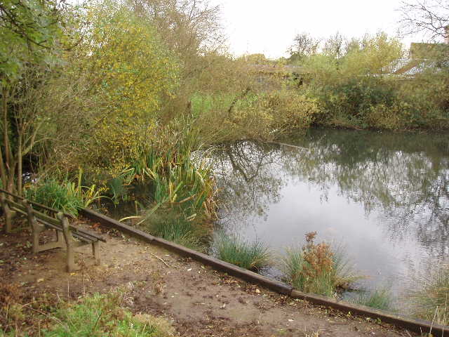
[1] Village pond, Sandon
I followed the road from Sandon church, and continued ahead at a junction [1], following the road towards Buntingford. After a short distance, immediately past the last house, I took a footpath on the right that crossed a field diagonally. The top half of the field was grass, but the lower half was a vegetable crop and until I got close to it I couldn’t see the path through it and thought I might have to walk round it. In the corner of the field to my left were a pair of Gipsy caravans. In the far corner of the field, I went through a hedge and turned left to follow it, with a very large field (vegetables again) on my right. At the next field corner, I turned right and continued beside another hedge with the same field on my right. After a couple of hundred yards, I turned left over a stile into a rough pasture that had evidently had cattle in it very recently. In a few yards I crossed a footbridge over a tiny stream, and a further few yards on I went through a gate on my right. Here I turned left to follow another hedge for a few hundred yards, to reach a lane opposite a farm.
I turned left along the lane for about 50 yards, then took a footpath on the right. This went through a small paddock (with some very tiny jumps for ponies), then continued on the same line through another vegetable field. There were some nice views here over the fields to my left [2]. The path through the vegetables was narrow, but clear enough, so the footpath is obviously quite well used. The path took me to the right-hand end of a hedge, beyond which the path continued in the same direction, going downhill beside a wire fence on the left. At the field corner at the bottom of the slope, I turned left through a gate and after a few yards went through a gap in the hedge on the right. I immediately turned left, and continued along the bottom of this shallow valley through a sequence of kissing gates. Eventually, one of these gates took me into a pasture on my right.
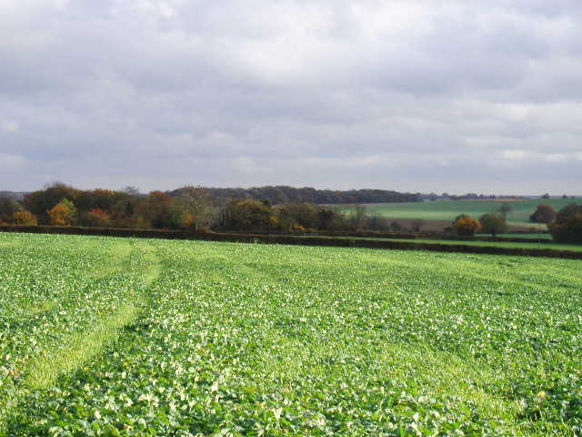
[2] View east from path heading towards Mill End
Here I went wrong. The guide book and the waymarks indicated that there were two paths here, and I needed to take the one further right. I saw a stile in a fence halfway up the hill, and went there, thinking that the left-hand path went through a gate at the bottom of the hill. In fact, I was on the left-hand path, the path I wanted going straight up the hill to a gate in another fence (not visible from the valley bottom). I continued on the same line beyond the stile in another pasture – I compounded my mistake by getting right and left confused (you’d be amazed how often I have to correct myself when writing these journals!). The guide book mentioned passing a low building on the left, and I thought I was dong that – it was only later I realised that it was on my right! Doh! I went through a couple of kissing gates and along a passageway between fences to reach a lane in Mill End. I turned right and soon reached a footpath on my right – I went a short way down it, before realising it didn’t match the description in the guide book. It was then that I realised my mistake, and saw that this path was the one that I should have been on when I reached Mill End. So I turned and went back to the lane, turned right again and soon found the correct path. I did go the correct way back on my return journey, but it was a bit fiddly, overgrown in places (I snagged my rucksack on a low branch) and went through someone’s garden – I think the way I went by mistake was actually a better route, although slightly longer.
The correct path out of Mill End followed a left hand electric fence beside a field that had just been ploughed. There were a couple of horses in the large paddock on the other side of the fence. Where the fence ended, the path continued beside a hedge that turned towards the left. In the field corner, I went through the hedge and continued in the same direction in a large grass field that sloped gently downwards. Again there were pleasant views here. The true course of the footpath wasn’t obvious here, but I could follow a track that went in roughly the correct direction, towards Whitehall farm (which I recognised from my previous walk). I went over a stile into an orchard, rejoining the route of Walk 12. I turned right and went through a couple of kissing gates, then passed assorted farm machinery on my left. I followed a good track leading away from the farm, with a hedge on my right. At the end of the second field, the track turned to the right. A few yards further on I had to look for the footbridge over a ditch on my left – there was no signpost indicating where the footpath went here. The path now followed the right hand hedge of a large stubble field, before turning half-left to cut a large corner of the field [3], passing the overgrown pond I’d seen two days ago. Beyond the next hedge, the path was faintly visible in the grass of two large fields. Beyond the second field I reached a lane – this was the point where the section common to Walks 12 and 13 ended.
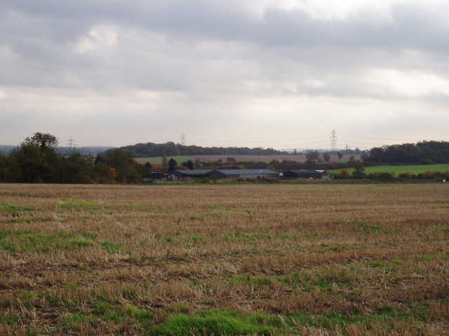
[3] Looking back towards Whitehall farm
Walk 13 turned right here, but I needed to turn left to finish walking Walk 12 in the anti-clockwise direction. There was little of incident to report on this section of today’s walk. I saw a Red Admiral near Cottered (I’ve seen one on almost every walk recently, but have forgotten to mention them). Annoyingly, after taking a photo in Cottered, my camera said that the memory card was full. After my 512M card packed up on my last walk, I’d put in my spare 16M card, but had forgotten to reduce the picture quality setting so I could only get 5 or 6 photos on it! When I entered the last (ploughed field) before reaching Whitehall farm again, a black and white border collie suddenly appeared beside me – very friendly, wagging its tail. It followed me for the next couple of hundred yards, but just as I was beginning to worry that I was going to have its company for the rest of the walk it turned back – I heard people shooting in the nearby woods, so I supposed it was with them (as you’ll see, I later found out it belonged to the farm). It took me about an hour and three quarters to walk the 5.5 miles of Walk 12 and return to the lane, where I turned right to continue my clockwise walk along Walk 13 of the Hertfordshire Chain Walk.
After a few hundred yards the lane turned sharply right. But I continued ahead on a track between hedges which soon emerged into a field. Here I followed the left hand-hedge for about 300 yards, until a post with waymarks indicated where two paths crossed. Here I turned right across the recently ploughed and planted field – there was no sign of the path and I had to make my own way across, heading towards a bungalow with a small paddock in front of it. Just before I reached the paddock, two dogs came running out towards me barking fiercely. They didn’t bite (fortunately – I did get bit by a small terrier on one of my local walks a few months ago, an incident that I reported to the police) but the larger dog in particular was very aggressive. I didn’t hear anyone call, but after a few seconds of me shouting at the dogs, they did go back to where they came from, and I made my way through a kissing gate, across the paddock, and through another kissing gate onto the drive outside the bungalow.
Here I turned right, then went left into the garden of another property. I walked across a grass strip to reach a gate into a field. Again there was no sign of a path in this ploughed and planted field, but I followed the instructions in the guide book and managed to find a footbridge across a ditch on the far side. Still no sign of a path in the next field, so I started out towards a lone tree in the middle of the field, then turning left towards a gap in the far hedge, as per the guide book. In fact, when I reached the hedge gap I could see a faint line of footprints coming directly from the footbridge, so that was the way I went on my return trip. Beyond the hedge gap was the large green at Roe Green – it was now 1.25pm so I stopped for lunch on a bench by a football pitch here.
On the far side of the green, across the road through the village, I picked up a path that was familiar to me from the Hertfordshire Way and my Berks-Essex walk. This crossed a small paddock then ran between the wooden fences of other small paddocks to a larger paddock. These paddocks were empty, but there were two horses close to the path in the following large field – two people were having a bonfire in the field to my right (a bit late for Guy Fawkes, I thought!). There were two more horses in the next large grassy field too, but a long way away from the path. On the far side of this field, I reached the road running through Sandon.
The Hertfordshire Way and the Icknield Way (part of which I followed on my Berks-Essex Walk) both follow the road through the village to the church, but the Hertfordshire Chain Walk takes a footpath on the other side of the road and follows it left through a narrow field of rough grass. Officially (and according to the guide book) the footpath then enters the grounds of the village school, but this path seems to be blocked by a fence, and instead a permissive path leads round on the other side of a hedge from the school. I followed this path as it followed the hedge and turned with it to the left, to then go down a short alley between the school and a house to return to the road. It was then just a short stroll to my right to reach a road junction, with the church then just a few yards to the left.
The church clock struck two just as I turned round. It seemed a bit late to be turning round and starting my journey back, but of course I’d actually walked two thirds of the way already – I only had to walk back the route of Walk 13, having walked Walk 12 in the other direction on my last walk. I had to brave the barking dogs again – I thought I’d managed to avoid them, but they came barking after me just after I’d left the paddock and started across the field. Again I had to turn and shout at the larger dog before it slunk off home. On the far side of that field, where there was a crossroads of paths, I met a rambler coming from the opposite direction who turned to go the same way as me. We got talking – he was a member of the Royston branch of the Ramblers Association who lived in Buntingford, and he was out checking the route of a walk he was going to lead in a couple of week’s time. He knew the Hertfordshire Chain Walk well, and had also walked the Hertfordshire Way. Where I turned left to walk the stretch that is common to both Walks 12 and 13, he continued on ahead in the direction of Cottered.
As I approached Whitehall farm (for the third time today!), I saw two dogs on the far side of the field following the farmer on his tractor. One barked and ran across the field towards me – I didn’t mind, because it was wagging its tail and was obviously the collie that had followed me earlier. It came up to me, and followed me as I went past all the farm machinery again and through the orchard. It went under the fence as I climbed the stile into the next big grassy field, but wouldn’t go any further.
Apart from the short bright spell in the morning, it had been grey and gloomy most of the day. With the dark grey clouds and the fading light (it’s only about six weeks to the shortest day) by the time I returned to Sandon at about 3.40pm I think it was the darkest it has ever been on any of my walks so far.
I was a bit disappointed with this walk, and didn’t enjoy it as much as I usually do. I think this could partly because I was tired and had a headache, partly because I was annoyed with the aggressive dogs and partly because I got fed up with paths not being reinstated after ploughing (I thought of contacting the council about this, but I guess the farmer’s are allowed a few days grace before doing this and the fields had obviously only been ploughed very recently). I was also frustrated about not being able to take any photos. Still, it certainly beat sitting in a stuffy office shouting at a computer screen! I remember thinking, when I was a couple of fields away from the end of the walk, that it hadn’t really been too bad at all. There had been some nice views over the rolling countryside, especially near Whitehall farm. Unfortunately many other views were spoilt by two lines of giant pylons that crossed the countryside in this area.
Total Distance: 75.25 miles (each way)