Pete's Walks - Hertfordshire Chain Walk
If you are considering walking this route yourself, please see my disclaimer. You may also like to see these notes about the maps and GPX files.
Walks 11 and 12 13/11/06 Cottered (4.25 miles each way, plus 5.5 one way)
Parked in cul-de-sac in Cottered.
(NOTE: I had a problem with my camera today, so the photos on this page were actually taken on the previous and following walks. As usual, I have put the date alongside the captions to show that the photos were taken on a different day).
The week and a half gap since my last walk on the Hertfordshire Chain Walk was because last week I went on a four-day walking holiday in Sedbergh. This was with HF Holidays again (I stayed at their Sedbergh house earlier this year when I walked A Dales Walk). We walked up Whernside from near Dent, visited Wensleydale and Swaledale, and crossed Middleton Fell which is just south of Sedbergh. So I have not been idle since my last journal entry!
Today I walked Walk 11 (‘Cottered going South’) both ways and Walk 12 (‘Cottered going North’) one way. On my next walk, I shall walk Walk 12 in the opposite direction, and walk Walk 13 both ways. Today’s walk was therefore a total of 14 miles, the next walk will be 15.5 miles, both close to my average distance of 15 miles. If I did not split Walk 12 between the two days, I would have had some very short days or an extremely long day walking both ways round two legs of the Hertfordshire Chain Walk.
Walk 11 starts by going south along what the guide book calls a ‘cul-de-sac’ (really a dead-end lane with a few dwellings along it) for 300-400 yards, then taking a track round the side of a house. The route has then been diverted, as instead of going through a garden it takes a short passage between a hedge and a fence to reach a field corner. I crossed the grass field diagonally, the path through the grass being clear, and went through a kissing gate to reach a green lane. I turned right and followed the hedge-lined track for a few hundred yards, passing one house beyond which the lane was surfaced. I then turned left on a footpath heading gently uphill, with a hedge on my left and a fence on my right. Where these ended, I continued ahead across a large field that had been ploughed fairly recently – although muddy, I could see the line of the path quite clearly. On the far side of the field, the path went slightly right through a small area of saplings (I saw a group of Fallow deer here on my return trip) to reach a footbridge over a ditch into a field.
I turned left here, following the hedge. There were some huge stacks of straw bales beside the path. At the field corner, I crossed into the next field, and turned right to follow the hedge for several hundred yards, with nice views towards a wood ahead of me. At the next field corner, the path crossed a bridge to my right, and then continued in the same southerly direction as before, now with the wood and then a hedge on my left. This section of the route was very muddy. At the next field corner, which was slightly overgrown, the path went through the hedge to join another green lane, coming in from my right but now turning to continue ahead in the same direction as I’d been walking. As usual with green lanes, I particularly enjoyed this part of the walk. It was a bit muddy in places, but not bad. Some sections had recently been resurfaced with gravel and builder’s rubble – unfortunately this seemed to include several pieces of glass and some broken pottery. After several hundred yards, I came to a junction with Back Lane, the Roman Road I’d walked on the last leg – the next section would be repeating part of that walk.
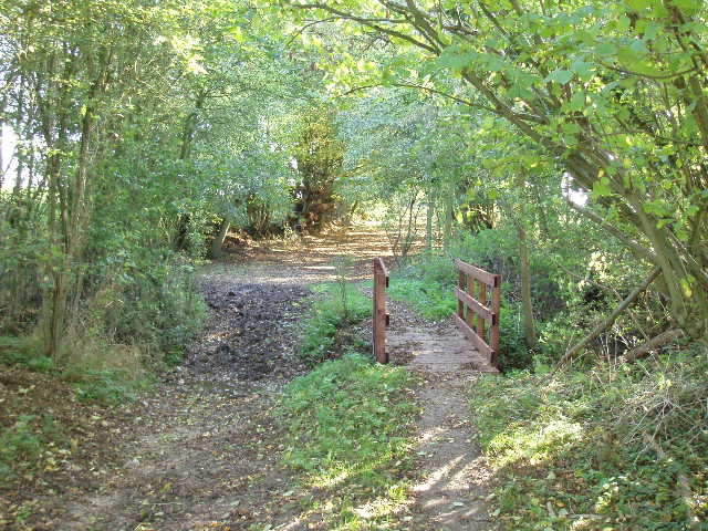
[1] Back Lane and the footbridge over the Old Bourne 2/11/06
Here I turned right, immediately crossing a wooden footbridge over the Old Bourne [1]. I’d come across this on a couple of other walks recently, where it had been bone dry, but today there were a few inches of water in it – I’d been following it’s course more or less for almost a mile (it forms the parish boundary hereabouts). Just a few yards later, I went left through a gate, then crossed a grassy field half-right to a corner of a wood (I automatically went through the redundant kissing-gate [2] here again). I continued on in the same direction, passing through a gap in a hedge to reach the field with all the humps and hollows that I’d noticed last time. Beyond this field, I followed a path beside the gardens of a farmhouse (actually, there was also a small paddock here with a grey pony that was initially startled when I suddenly appeared, but then came over to the fence to let me stroke it). Where the path reached the drive to the farmhouse, I left the route of the previous walk by turning right towards the farmhouse (the green at Moor Green was to my left). I then turned sharp left in front of a barn conversion, and continued ahead on a track, initially with paddocks on my left, then running between low hedges. The track bent to the right, towards another wood. Before it reached the wood, I went through a kissing gate on the left and crossed a large open field to the corner of a hedge. A very elaborate and obviously fairly new stile (actually a squeeze stile, a step stile then another squeeze stile!) gave access to another paddock, with two horses a long way off to my left. Curiously, the path through here crossed a causeway through a pond (the causeway was being built when the guide book was being written). Another kissing gate then took me on to another section of Back Lane, where I turned left.
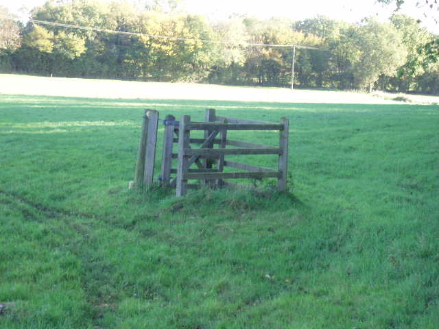
[2] The redundant kissing-gate near Moor Green 2/11/06
After a pleasant section of about 300-400 yards along the old Roman road, I turned right on a path that followed the left edge of a huge field. I had a wood on my left, and in the distance I saw a group of about a dozen Fallow deer on the far side of the field. Where the wood ended, I went through a gap into the field on my left and crossed it diagonally – there was no sign of a path, and my boots gathered a lot of mud as I crossed the recently planted cereal crop. On the far side, I went through a gate in a farm yard and walked past some more barn conversions to reach a lane. I followed this to the right for a few hundred yards, then took a footpath on the left. This ran between a left-hand hedge and a wooden fence, with a large grass field beyond the fence. The path went slightly downhill then rose again, before going through the hedge to join another green lane. A few hundred yards further on, I took a footpath on the right. This crossed an empty grass field to a stile, beyond which I crossed a large pasture containing an assortment of cattle (cows, bullocks and calves) to reach the playing fields back in Cottered. I walked along the right edge of the playing field, with the road through the village over to my left, to reach the dead-end lane where I’d started. I turned left and walked the short distance to my left to complete Walk 11 of the Hertfordshire Chain Walk. It had taken me about an hour and twenty minutes to walk the four and a quarter miles, having set off at about 10.15am.
Starting Walk 12, I went to the end of the lane and turned left along the main road (Note: I’ll describe Walk 12 in this journal entry rather than the next one, as today I walked it in the clockwise direction followed in the guide book). After a few hundred yards, I turned right along a track next to the village pub. After a couple of twists and turns this emerged into a huge open field. The guide book gives extensive directions as to where you need to go here, but in fact the path was perfectly obvious, there being a broad strip through the grass crossing the field half-right. It was quite a long walk crossing this enormous open field, the ground rising slightly, but I eventually reached the hedge on the far side. In the next field, I turned left to follow the hedge. Where the hedge turned slightly left, the path carried on ahead cutting the corner of the field. I then turned right along the opposite hedgerow, with the same field on my right. At the next field corner, I went through a thin belt of trees to reach a path junction. I turned left along the edge of a ploughed field (no sign of the path, though I saw a couple of waymarks). Where the tall hedge on my left ended I turned right to cross the ploughed field [3] towards a distant pole (part of a power line), then turned half left to reach a lane by a footpath sign – again my boots were caked in mud.
I followed the lane a good distance to the left. I passed the entrance to one farm on my right, then went close to a second farm where several builders’ vans were parked. There were some nice views over the undulating countryside round about. A bit further on, the lane became a concrete track as it passed between farm building, becoming tarmac again as it passed a bungalow and a house. As I continued onwards, with another large open field on my right, I had a good view of a Hare scurrying across the field, the first one I’ve seen so far on this walk. Just before a junction, I turned right to cross the field (this was the start of the section that is shared with the next walk). The directions in the guide book were unnecessary, as again the path was perfectly clear, as it was in the next grassy field. Having passed through a hedge, I turned half left across a field of stubble, passing what the guide book described as a pond surrounded by bushes on my right – in fact, there was no sign of water there anymore and the bushes were growing right across the small depression where the pond had once been.
On the far side of the field, I turned right to walk with the hedge on my left. In the field corner, I went through the hedge and turned right on a good farm track. This soon entered another field and turned left to follow the hedgeline. It went through an open gate and continued alongside the hedge towards Whitehall farm. I walked past a large quantity of farm equipment on my right, then a kissing gate led into a small orchard with a bungalow to my right (the route of the next walk comes in from the left at this point). Beyond the orchard I crossed a farmyard and went through a gateway into a ploughed field. I had to make my own way half right across the muddy field to the far hedge, which I then followed to my left. Soon I was walking with a wood on my left, and an open field to my right. Again there were some nice views of rolling countryside on this section of the walk, with several woods amongst the patchwork of fields. At the end of the wood I turned right and followed a shallow ditch. Where this turned right I continued ahead, following a pair of tractor tracks that marked the route of the path through a crop of vegetables.
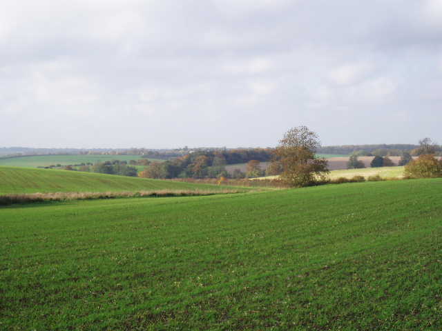
[3] View from pathless field south of Broadfield Hall 15/11/06
The path went through a hedge – there was some speedwell on the ground on the other side, one of the few occasions I’ve seen any wildflowers on this walk (common field speedwell flowers all the year round). There was now a wood on the right, but the path went half-left crossing the field (grassy scrub) and continued on the same line through two or three empty grass pastures. There was a farm and horses in a paddock to my right (actually there was a grand house there as well, Broadfield Hall, but somehow I didn’t notice it until I came back in the opposite direction on my next walk), a small wood or copse over to my left. The path next crossed the lane that I’d walked on earlier, and then turned half left to cross a sequence of four or five paddocks diagonally. As I crossed one of these, one of three horses in an adjoining paddock approached the electric fence that separated us, but I must have made a sudden movement that spooked it as it suddenly turned and dashed away a short distance. One of the paddocks was completely overgrown with long grass that came up to my knees in places. Beyond the paddock, I went through a hedge into a huge open grass field. I followed the instructions in the guide book, and started out towards a point just right of a tall pylon, then halfway to it I turned left. When I turned, I could then see a faint darker mark through the grass where the path went – I’d have been on it if I’d aimed straight at the pylon. It was a long way across the field. On the other side, I went through a gate and through a farmyard, following the farm’s drive to a minor road. I turned left (turning right into Cottered would have shortened the route by half a mile) and followed the road for about a quarter of a mile with a few well spaced properties on my right.
Immediately beyond the last house, I took a path on the right that crossed a field diagonally and continued on the same line across the next grassy field to reach an impressive old oak tree on the far side. There were some nice views here. The Hertfordshire Chain Walk then almost doubled back on itself to re-cross the field, reaching the corner that had been on my right when I first entered the field. The path continued in the same direction in the next field (stubble, if I remember correctly) to a hedge corner. It went through a gap and followed the hedge a short distance before crossing a ploughed field (tractor tracks marked the route) to reach the main road on the eastern edge of Cottered. I crossed the road and took the path opposite, that went along the edge of a field with the ends of gardens on my right. At the far end of the field, I went through a gap on my right onto a driveway and a few yards later reached the lane where I had started my walk this morning. I turned right and reached my car in about 100 yards.

[4] Cottered 15/11/06
It was now about 1.35pm. I started to retrace the route of Walk 11, but stopped almost immediately to have lunch on a bench beside the playing field in Cottered [4]. I was lucky with the weather today – some scattered showers had been forecast, but I only had them as I drove to Cottered. For the rest of the day it remained dry, although there were always dark grey clouds in the sky that threatened showers. It was never overcast however, there were always patches of blue sky. The weather was more like that back in October, rather than the bright and cold days at the beginning of November. Again it only took about an hour and a quarter to follow the route of Walk 11, and I was back at my car (yet again!) by about 3.10pm. After changing out of my muddy boots, I drove the short distance to Cottered church (which wasn’t on today’s route). This dates mainly from the 15th century, and has a large wall painting of St Christopher – I enjoyed my short visit here.
This was a pleasant but unexceptional walk. The route was a bit fiddly in places and I had to keep paying close attention to the guide book. Where the guide book was occasionally out-of-date, it was always quite apparent where the path went. I think I was still a bit tired after walking four successive days last week, so I might have enjoyed this walk more if I’d been feeling a bit fresher. Apart from Cottered, I didn’t go through any villages, just touching on the hamlet of Moor Green again and passing isolated farms and cottages. The countryside was nice, with occasional good views but not as many as on a couple of recent walks.
When I got home, I found I couldn’t load my photos onto my PC. Then I found when I put the memory card back into the camera, it said ‘card error’. It wouldn’t even let me reformat the card, so as well as losing today’s photos the card is knackered and I need to buy another one.
Total Distance: 64.75 miles (each way), plus 5.5 miles one way