Pete's Walks - The South Bucks Way
If you are considering walking this route yourself, please see my disclaimer. You may also like to see these notes about the maps and GPX files.
Day 1 15/08/05 Coombe Hill to near Little Missenden (8.5 miles each way)
Parked at Coombe Hill car park.
It was sunny when I left home, but I noticed it was quite misty when I reached Whipsnade Zoo and by the time I reached the car park for Coombe Hill it was pretty foggy. Walking the third of a mile to the start of the South Bucks Way, I was beginning to wonder if I was going the right way, as there was no sign of the tall monument that crowns the hill (a memorial to soldiers who died in the 2nd Boer War). Eventually, I saw the monument looming out of the mist ahead of me. Visibility was down to about 100 yards – there was no sign of the glorious views that you normally get from this hill.
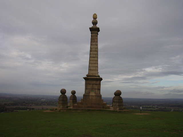
The monument on Combe Hill 5/11/05
I set off from the monument through the fog, following the signs for the Ridgeway path – the South Bucks Way shares its route for the first mile or so. After a short traverse of open hillside, the path entered a beech wood and soon reached a road (the one to the car park). This was followed downhill for about 100 yards, and then another path led through more beech wood. It felt more like autumn than August, walking through the trees in the mist. After a short downhill section, the South Bucks Way left the Ridgeway path and followed the route of the Icknield Way instead [Update 25/01/10 I now realise that this must have been the Icknield Way Trail, a long distance bridleway, rather than the Icknield Way footpath], gradually rising through more beech wood.
I managed to get lost here (if you’ve read my Chiltern Way journal, you’ll know that this is not that uncommon an event!). I missed a turning that cut a corner, which meant I came to a T-junction of tracks where there were no signs. Having looked a few yards to the left, and then gone to the right, I soon found a signpost, and could see from the map where I was and where I’d gone wrong. I tried to go back the way I should have come, but compounded my mistake by taking the wrong path! In fairness, the path I should have taken was very faint and the only sign was hard to see, whereas the path I took was clear and there was an obvious sign. When I discovered my mistake and eventually took the correct path, I found that where I’d originally missed a turn the path was very narrow and the sign (a blue arrow painted on a tree) was quite hard to see.
While I was blundering about here, I heard the distinctive sound of a Red Kite (if you’ve read my Chiltern Way journal you’ll know I’m very fond of these birds). This was good news, as it was a little further east than any I’d seen or heard before, so their range is a little nearer to where I live than I thought.
Eventually I made my way through the beech wood to the tiny and very remote hamlet of Little Hampden, where the South Bucks Way parted company from the Icknield Way. I followed the lane through the hamlet for about a quarter of a mile, before turning left into another small wood, joining the Chiltern Way as I did so – in fact, I had walked this next section only about 10 days ago! The other side of the wood opened onto a field (where I again heard a Red Kite, about a mile further east than any I’d heard or seen on my Chiltern Way walk). The path followed a right-hand hedge downhill and then switched to the other side of the hedge and followed it up the other side of the valley – the valley bottom was fairly clear but the hilltops were still in the fog. I continued steeply uphill through a small wood, then crossed two pastures to reach the hamlet of Cobblers Hill.
Here, the South Bucks Way left the Chiltern Way, and made it its own route along a bridleway between fields, before turning off left through another wood. It then went downhill across fields and then under a railway line to reach a road at Mobwell. Opposite the pub there (where they do trips in hot air balloons sometimes, according to the leaflet from Bucks County Council), the currently dried up Mobwell pond was the source of the river Misbourne, which I will be following for much of this walk. The South Bucks Way then threaded its way between the busy A413 and the outskirts of Great Missenden, using a variety of field paths and paths between houses, eventually crossing the parkland in front of Missenden Abbey. Having crossed a road, the path then went round two sides of a school playing field. Some bungalows backed onto the school field. One had a gate with a sign saying ‘Our Dog loves children – but it couldn’t eat a whole one’. The next gate said ‘Never mind the dog – beware the owner!’.
It was about this time that the last of the fog disappeared, and the rest of the walk was in bright and warm sunshine. Having passed under the railway line again, the path went through a couple of grassy fields to reach the residential area of Little Kingshill. Here a path between garden fences led steeply uphill to a private drive, which in turn led to a lane. A short path from the lane led to a small recreation area and a road. The South Bucks Way followed the road for about half a mile (on a good pavement, it was still in Little Kingshill) before a short bit of green lane led to a footpath through a couple of large corn fields (the corn had been harvested, there was just stubble in the fields). The view was magnificent as I walked through these fields. The fields covered a small ridge of hill, with the Misbourne valley to the left and another tributary valley coming in on the right – the ridge I was on gradually descending to where the valleys met. The far side of each valley was crowned with woods, and ahead I had an extensive view over Little Missenden and further down the Misbourne Valley. This was as good a view as any I’d seen on my recent Chiltern Way walk. To cap it all, I heard the distinct sound of a Red Kite, and looking over to the woods on my right managed to spot it soaring over the trees. Perfect!
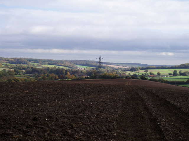
View from near Little Kingshill towards Little Missenden 5/11/05 (I'm afraid the photo doesn't do justice to the view, which is sadly spoilt anyway by the obtrusive pylon)
At the bottom of the ridge, I turned round and started back to Coombe Hill. It had taken me almost 3 hours to reach my turn round point, and I was quite concerned that my walk was going to take nearer six hours than the five I usually walk. I stopped for lunch after the long road walk through Little Kingshill, at a bench by the recreation area. There was a noticeboard there about the parish of Little Missenden, with details of places of historic or other interest. It actually recommended where I’d just been as a viewpoint, so I’m not the only one to be impressed with that view.
It was much pleasanter walking back through the beech woods when the mist and fog had gone, and when I arrived back at the monument at Coombe Hill I paused to take in the marvellous views that I’d missed in the morning. I could probably see 30 or 40 miles, as opposed to just 100 yards! The views were magnificent, I have to admit they are probably the equal, if not better, than those from Dunstable Downs, my local favourite.
Total distance: 8.5 miles each way
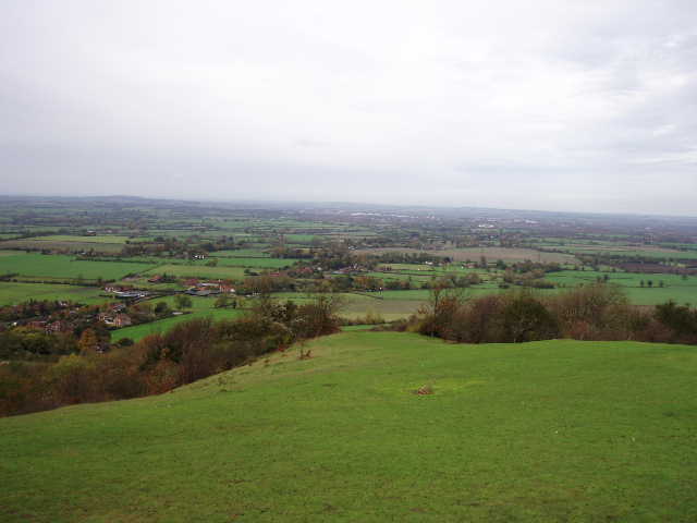
View from Combe Hill 5/11/05