Pete's Walks - The South Bucks Way
If you are considering walking this route yourself, please see my disclaimer. You may also like to see these notes about the maps and GPX files.
Day 2 16/8/05 Near Little Missenden to Chalfont St Peter (8.5 miles each way)
Parked at Ash Grove picnic site near Little Missenden. (UPDATE 4/2/12: This car park is now closed!)
(Note on parking place: this was one of the parking places recommended on the leaflet from Bucks County Council. It was fine for me, but to get to it you have to turn off the A413 where it is dual carriageway. To get to the South Bucks Way, you therefore have to cross the dual carriage way, although I managed this quite safely both times. Also, when you leave the car park you must turn left when you reach the dual carriageway – fortunately there is a roundabout about a mile in that direction where you can turn round and head back towards Great Missenden, Wendover, etc., if you need to go that way.(UPDATE 4/2/12: This car park is now closed!)
I walked down the road, steeply downhill, from the car park, crossed the A413 dual carriageway and followed a bridleway for a few hundred yards to reach the South Bucks Way just east of Little Missenden. I had turned round just west of the village on the previous day’s walk, so I first had to walk westwards through the village and along a broad track through a corn field (stubble) to reach that turning point.
I hadn’t appreciated how hot it was going to be when I left home. Almost as soon as I’d reached the South Bucks Way I changed my glasses for my sunglasses, and shortly after turning round I stopped and unzipped the lower parts of my trousers to convert them into shorts (this probably amused or confused some horse riders who passed me at this point!). I was worried that if it was this hot just after 10am, how hot would it be later on? Fortunately, a cool but slight breeze sprang up, and although the rest of the day was very warm (mid to high 20’s, I’d guess) it never got unbearably hot.
From Little Missenden, the South Bucks Way followed the valley of the river Misbourne through some grassy meadows, and then through the parkland of Shardeloes, a grand house visible on the hilltop to the right of the path. It then crossed a cricket pitch and went through an underpass under the A413, to reach the road into Old Amersham. This was quite pleasant to walk through, the High Street being very long and full of mainly Georgian properties (many were probably older, with Georgian facades). Back into the countryside, the path went through another underpass beneath the A413. In the next field, another grassy meadow, there was no sign of the footpath as shown on the map, and I had to make my own way following the map as closely as I could. On the way back, I followed the ‘de facto’ path and later saw that this was the route shown on the information leaflet about the South Bucks Way. This was by no means the first or last time that there was a discrepancy between the map, the route on the ground and/or the leaflet.
The next field was being ploughed. I mention this, as apart from a couple of corn fields near Little Missenden, every field I walked through was grass. A few fields further on, I met a couple of lady walkers resting by a stile. They were members of the Women’s Institute, celebrating 85 years of the WI in Buckinghamshire by walking through the county from north to south, their route incorporating both the North Bucks Way and the South Bucks Way (one of the ladies had missed this section when the group did it, so that was why she was doing it with just her friend). Shortly after this, I came across another section where the South Bucks Way shared its route with the Chiltern Way, so I was on familiar territory as I reached Chalfont St Giles.
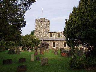
Chalfont St Giles church 26/10/05
From the centre of the village, the path went through an archway and followed a fenced path round the outside of the churchyard. Here, by a footbridge, I knew I needed to branch off the Chiltern Way, but it wasn’t obvious where the South Bucks Way went – there was no sign or waymark. Eventually, I saw a stile on the far side of the garden of a block of flats, and having walked across the garden I found a South Bucks Way waymark on it. Beyond the stile the path was well waymarked as it led on over several more grassy meadows for a couple of miles, to reach the outskirts of Chalfont St Peter (although the route on the ground differed from that shown on the map). Here, the waymarks disappeared completely – I went wrong straight away, and had to backtrack 100 yards, because I kept to the main path where I needed to fork left onto a much narrower path – there was no sign at all at this junction. I eventually made my way, guided by the map, across a playing field, beside some allotments and across a car park to reach the centre of Chalfont St Peter by its church.
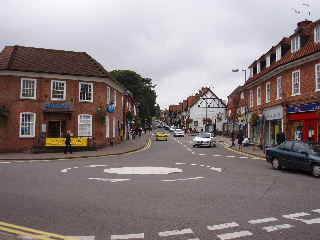
Chalfont St Peter 26/10/05
Here I turned round and made my way back, stopping to eat my lunch on a stile between Chalfont St Peter and Chalfont St Giles. The afternoon walk was a bit of a drag really, mainly because this was my second 17-mile walk on successive days, both of which had been quite hot, but also because I found today’s route to be somewhat monotonous. It was completely flat (apart from the path from the South Bucks Way to the car park), almost entirely through the same type of grassy field, and although it was at the bottom of the valley of the river Misbourne, I didn’t really have the pleasure of walking alongside the river. I only saw the river twice, once at the underpass near Old Amersham and once when I crossed it en route from the car park to the South Bucks Way. The views were very limited, mainly just the valley ahead - I couldn’t always even see the top of the hillside to my right. Also, there was the constant drone of traffic on the A413 that also follows this valley – most of the time my brain filtered out the traffic noise, but when I became aware of it, it was annoying.
All in all, this was not one of the better walks I have done recently. Having said that, it wasn’t really that bad – it certainly beat sitting at home or in an office! If it hadn’t been so hot, and I hadn’t been tired from the previous day’s walk, I would probably have enjoyed this one much more.
Total distance: 17 miles each way