Pete's Walks - Berkshire-Essex Walk
About the Berkshire-Essex Walk
If you’ve not heard of the Berkshire-Essex Walk before, that’s probably because I’ve just made it up! Unlike all the other long walks that I have done so far, this is a walk of my own making rather than a route defined as a long-distance path by other people.
So why should I want to do a walk from Berkshire to Essex? The answer is very simple. For sometime now I have wanted to walk both the Ridgeway path and the Icknield Way path. However, it simply isn’t feasible to do either of these two paths from my home in Kensworth as a series of day-walks, because the western end of the Ridgeway and the eastern end of the Icknield Way are simply too far away – it would take me two hours to drive there, and I don’t like to drive for more than an hour before a walk (if I was driving to somewhere where I could go mountain walking, that would be different!). So I decided to do a walk that would follow the parts of these two trails that are within easy reach of my home.
It was then easy to decide where to start my walk. The river Thames neatly divides the Ridgeway into two, the western part over the Wessex Downs and the eastern part over the Chiltern Hills. So it was an obvious choice to pick this natural barrier as my starting point. Also, I knew from my Chiltern Way walk that I could get there in about an hour. Selecting a destination along the Icknield Way was more problematical, as there was no obvious natural boundary about an hour’s drive east of my home. But then it occurred to me that the Thames between Streatley and Goring, as well as being a natural barrier, was also the county boundary between Berkshire and Oxfordshire. So why not make this a county-to-county walk, a bit like the Greensand Ridge Walk (which is effectively from Buckinghamshire to Cambridgeshire) or the Cross Bucks Way (Oxfordshire to Bedfordshire)? Initially, I chose Cambridgeshire as my destination, but while on my walk I realised that the first village in Essex was only a mile further on than the first (and only!) village I’d come to in Cambridgeshire, so I decided to carry on to Essex.
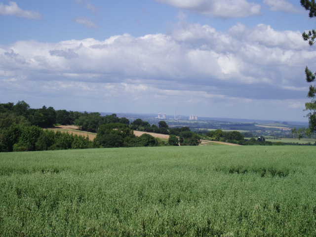
View out over Oxfordshire, to Didcot Power Station and Wittenham Clumps (Day 2)
So the route of this walk is very easy to describe. It starts at Streatley, on the Thames in Berkshire, and follows the Ridgeway path eastwards to its end at Ivinghoe Beacon. From there, it continues eastward along the Icknield Way path until it reaches Chrishall in Essex. The route covers approximately 44 of the 85 miles of the Ridgeway and 43 miles of the 110 miles of the Icknield Way (this last total is based on using the ‘northern alternative’ route avoiding Luton and Dunstable), a total distance of 97 miles.
The Ridgeway path is a National Trail, created in 1972 by The Countryside Commission. It runs from Overton Hill, in Wiltshire, to Ivinghoe Beacon, in Buckinghamshire. The Icknield Way trail is a Regional Recreational Route, officially opened in 1992, running from Ivinghoe Beacon to Knettishall Heath in Suffolk (with an alternative end at Thetford). Both paths follow the routes of prehistoric tracks that follow the line of chalk hills across southern England. In fact, these tracks extended from Dorset to Norfolk, and the Wessex Ridgeway now links Lyme Regis with the start of the Ridgeway, while the Peddar’s Way links the Icknield Way to the North Norfolk coast, thus providing a continuous route that could be termed the ‘Chalk Way’.
Incidentally, there can be some confusion over the Icknield Way. As well as the footpath, there is also an Icknield Way rider's trail for horse riders, which extends much farther west. Consequently, I came across Icknield Way waymarks while I was on the Ridgeway section of the walk - the rider's trail seemed to use identical, or very similar, waymarks to the footpath. Also, the route of the ancient Icknield Way is sometimes shown on the maps (in Gothic type, i.e. Icknield Way). So when looking at the map, one has to be careful to distinguish between the footpath, the rider's trail and the ancient route, all called the Icknield Way. Another slight confusion is that the Ridgeway path actually follows the old Icknield Way in places.
The Berkshire-Essex Walk connects with many of the other walks that I have done. The Chiltern Way is crossed many times by both the Ridgeway and Icknield Way sections of the walk. The Hertfordshire Way is met briefly just before Ivinghoe Beacon, then again several times later along the Icknield Way. Near Great Kimble, the start of the North Bucks Way is actually on the Ridgeway path. A few miles further east, the Ridgeway shares its route with the first mile or so of the South Bucks Way. At Wendover, the Ridgeway shares its route very briefly with both the Chiltern Link and the Aylesbury Ring. Ivinghoe Beacon is the start of the Two Ridges Link, connecting the Ridgeway with the Greensand Ridge Walk.
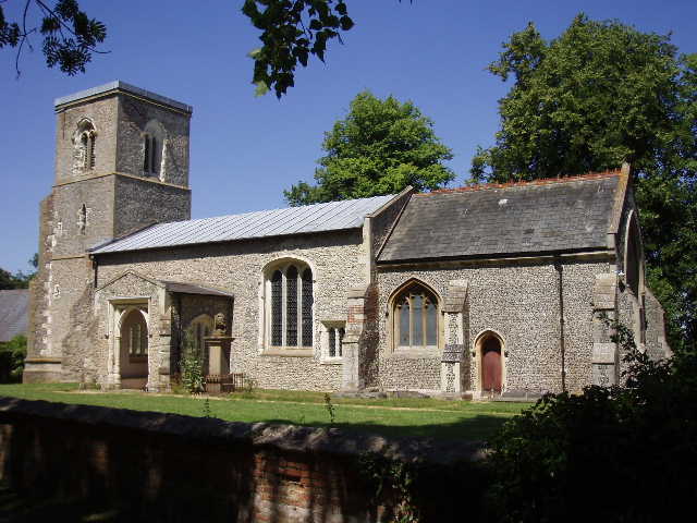
Wallington Church (Day 11)
The two guidebooks that I used for this walk are as follows:
- ‘The Ridgeway’ by Neil Curtis, Aurum Press, ISBN 1 85410 772 0
- ‘The Icknield Way Path – A Walker’s guide (4th Edition)’ written and published by The Icknield Way Association, ISBN 0 9521819 1 6
As usual, most of the factual stuff that I quote is taken from these two sources. The route is shown on the following OS Explorer maps (there are one or two very minor differences between the guide books and the maps): 171, 181, 192 (for only about 1 mile of the route!), 193,194 and 209.
Click here to see a very rough map of the Berkshire-Essex Walk (but only if you have already read my disclaimer and notes regarding maps).
Note: I have numbered each photograph (in red) and inserted the same number in the text to show where in the walk the photo was taken.