Pete's Walks - The North Bucks Way, Day 2
Day 2 3/9/05 Lower Hartwell to Quainton (7.0 miles each way, approximately)
Parked in side street in Lower Hartwell.
This was a really wonderful day’s walk, which I shall remember for a long time. As with the previous day, the weather was very good indeed, just a bit too warm to be perfect for walking (probably 25-26C in the afternoon). I had expected the walk to be very flat, like yesterday’s, but was pleasantly surprised to find it was quite hilly in places, with good views from the higher parts of the route.
I followed a short lane out of Lower Hartwell. Where it ended, the path continued across a large pasture and then beside the hedge of a field of stubble. Another cattle pasture then led to a farm, where the route turned from north to northwest and followed another hedgerow slightly downhill. A short section across a ploughed field led onto another pasture, which led downhill to the River Thame (not to be confused with the larger and better known Thames!). Here the North Bucks Way joined the Thame Valley Walk for a while, as it followed the river bank westwards through more pastures and fields. Opposite an impressive river-side house (a lodge on the Eythrope estate), I crossed a footbridge over a tributary or branch of the Thame, and then followed the drive of the house (a slightly raised causeway) to reach a junction with the long entrance drive into the estate, where the North Bucks Way again met the Aylesbury Ring walk. The drive went over a bridge by a weir in the Thame, and past another attractive Lodge. Heading north again, the drive passed through attractive parkland, with a glimpse of a pavilion in trees to the right and a very attractive view of a farm on a hillside to the left.
When the drive turned right, the North Bucks Way continues straight on through the grassy parkland, now also sharing its route with the Bernwood Jubilee Trail (more on this later). A bit further on, I was confused for a while as the map showed the path going straight across a field to join another drive, but there was no way through the thick hedge between the field and the drive. In fact I had to follow the hedge for about 150 yards before I found the stile. A short way along the tree-lined drive, I turned up a hedged-track leading gently uphill, and the path continued to a lane at yet another Lodge. This last stretch was actually part of at least five long-distance paths – the North Bucks Way, the Midshires Way, the Aylesbury Ring, the Swans Way and the Bernwood Jubilee Trail!
The lane led across the top of Waddesdon Hill, with glimpses of views down over the lower-lying surroundings, to a main road. Across this, the path went through Waddesdon Stables, across a paddock and then downhill through a small wood, and still downhill alongside a hedge. At the valley bottom there was an information board, partly about Black Poplars and partly about the Bernwood Forest. This was a royal hunting area in mediaeval times, covering parts of Buckinghamshire and Oxfordshire – the Bernwood Jubilee Trail had been created to encourage people to explore this area. It’s a circular walk of 61 miles, and I’m tempted to add it to my list of ‘Walks to be walked’ but as this was probably the nearest stretch of the walk to my home, it might involve too much travelling for me to do from home.
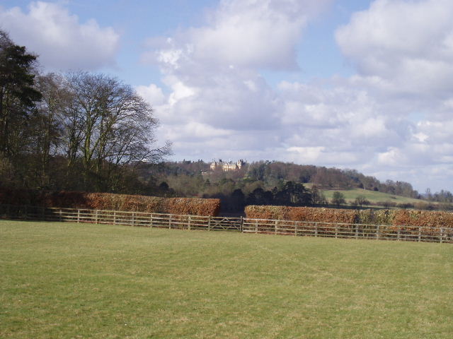
Distant view of Waddesdon Manor, from near Waddesdon Stud (2/3/06)
The scenery around this section of walk was very nice indeed, far hillier than I’d expected with nice views and occasional glimpses of Waddesdon Manor (built like a French Chateau for one of the Rothschild’s in the 19th Century, and now a very popular National Trust property). Although hilly, the scenery was different to the Chilterns, with wider valleys and less steep slopes.
The North Bucks Way continued past another farm and a few cottages, then through a small wood and across a stubble field to reach a footpath that went round two sides of a school playing field. I saw a large bird soaring in the sky here, but it was too far off to determine whether it was a Buzzard or a Red Kite. A path through some allotments then took me into the centre of the village of Waddesdon. A short lane took me back to the fields, the first being a cattle pasture, the next a grassy meadow with a strangely uneven surface where I was constantly concerned that I could turn my ankle. The next field was presumably ‘set aside’ as it was somewhat overgrown. I then stupidly went the wrong way – I crossed a stile onto a farm track and stupidly just assumed that was the way I should go. Luckily within about 50 yards I met a kind farmer who pointed me in the right direction.
The rest of the route to Quainton, about 2 miles, was almost all through cow pastures. About halfway, I had to cross a railway line, where I could see the steam from a train at the Buckinghamshire Railway Centre to my left. Apart from the climb up and down the railway embankment, this part of the walk was almost completely flat, although I could see Quainton Hill ahead of me (the start of my next walk on this journey). I could also see the impressive windmill at Quainton, the tallest in Buckinghamshire and currently being restored by volunteers.
After walking about 2¼ hours I reached Quainton, my goal for the day, and as usual I turned and started to retrace my steps. I stopped for lunch in the shade of some trees south of Waddesdon, just sitting in the grass by the side of the path. As I ate, I thought I could hear the distinctive sound of a Red Kite but wasn’t sure. Then I saw a bird high in the sky, but again wasn’t able to tell whether it was a Buzzard or a Red Kite. Then a Red Kite flew slowly by, almost straight over my head, very low just at the level of the treetops. It circled and came back a couple of times, so close and low that I had great views of its colours and its forked tail.
Although it was slightly warmer than I’d have liked, it was a thoroughly enjoyable walk with a great variety of scenery – farms, fields, the River Thame, the estates of Eythrope and Waddesdon, hills and valleys. I guess that is why so many long-distance paths go through here!
Total Distance: 14.6 miles each way